Build geography quizzes where players answer by clicking a real map — countries, capitals, rivers, historic sites or your own data. Share a link or QR code and let the leaderboard do the rest.
No credit card. No GIS degree. Players don't need an account.
Example quiz: Political map of the worldPlay it now
2 question types
Choose on the map or from a list, mixed in one quiz
Any map layer
Vector, raster and external layers become the quiz board
Link + QR code
Publish once, share in class, chat or on a poster
Top-5 leaderboard
Ranked by correct answers and completion time
Map quizzes for classrooms, geography fans and GIS teams
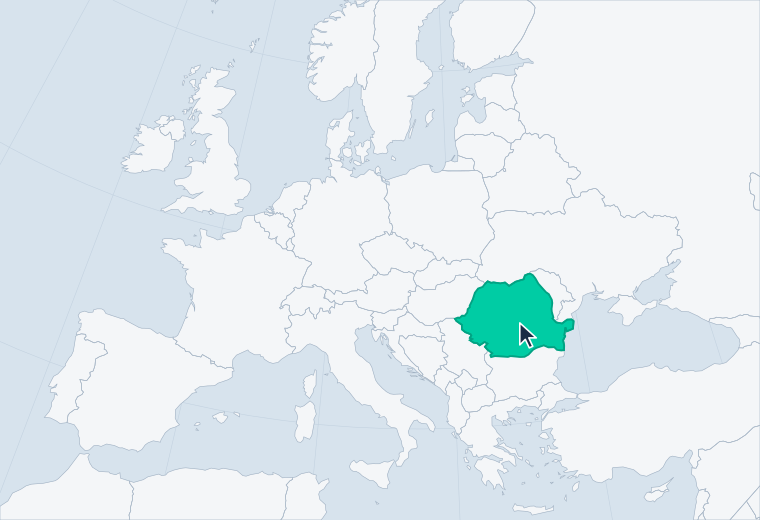
Most quiz tools show a picture of a map and ask you to pick a word. In GISCARTA the question runs on a live, zoomable web map, so players have to actually find the place — the way geography is really learned.
For teachers
Geography quizzes for students
Turn the map from today's lesson into a 10-minute check. Put the QR code on the board — students open the quiz in a browser, with no accounts and nothing to install.
Warm-ups, exit tickets and exam revision
Works for history, biology and earth science maps too
Reuse the same quiz with every class
For geography lovers
Quizzes on any theme you love
Capitals, rivers, volcanoes, battlefields, castles — pick a theme, build the quiz on a real map and challenge your friends to beat your time.
Start from ready-made global layers or your own data
Add a photo to make any question visual
Climb the top-5 leaderboard
For universities, museums & GIS teams
Tests built on your own spatial data
Use your layers — survey points, city districts, satellite imagery — to check what students, visitors or new colleagues really know about a place.
Vector, raster and external layers
Your logo, title and a link to your site
Upload CSV, GeoJSON, Shapefile, KML and more
How to create a map quiz in 4 steps
01
Start a new quiz
Open My Quizzes in the sidebar and click New Quiz. Start from scratch or copy an existing map project.
02
Set up the map
Add vector, raster or external layers, choose a basemap, set the starting view, legend, logo and title.
03
Write your questions
Name the quiz, add a description and reference links, then add questions: choose on the map or choose from a list.
04
Publish and share
Save and publish to get a link and a QR code. Players start the quiz, the timer runs, and the best five make the leaderboard.
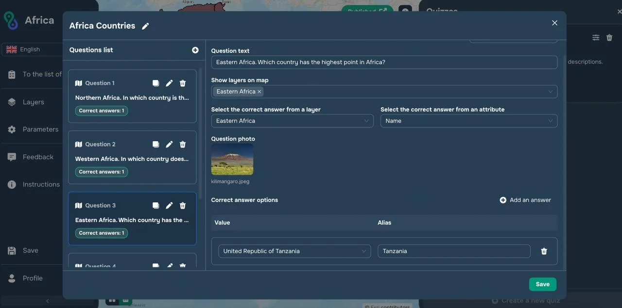
Everything happens in one window: write a question, choose which layers it shows, pick the correct answer and add a photo. Copy, edit or delete any question in a click, then save and publish. No code and no GIS skills needed.
The quiz builder: your questions on the left, the selected question’s settings on the right.
Two question types — mix them in one quiz
01Choose on the map
Players answer by clicking an object on the map — a country, a city, a river or any feature in your layers.
Pick the layer players click and the attribute that holds the answer, such as Name
Add one or more correct values from that attribute
Give an answer an alias, like “Tanzania” for “United Republic of Tanzania”
02Choose from a list
Players pick the answer from a list in the quiz panel, while the map stays on screen for context.
Write several answer options
Tick every correct one — more than one can be right
Options are shuffled, so their position gives nothing away
Everything a good geography quiz needs
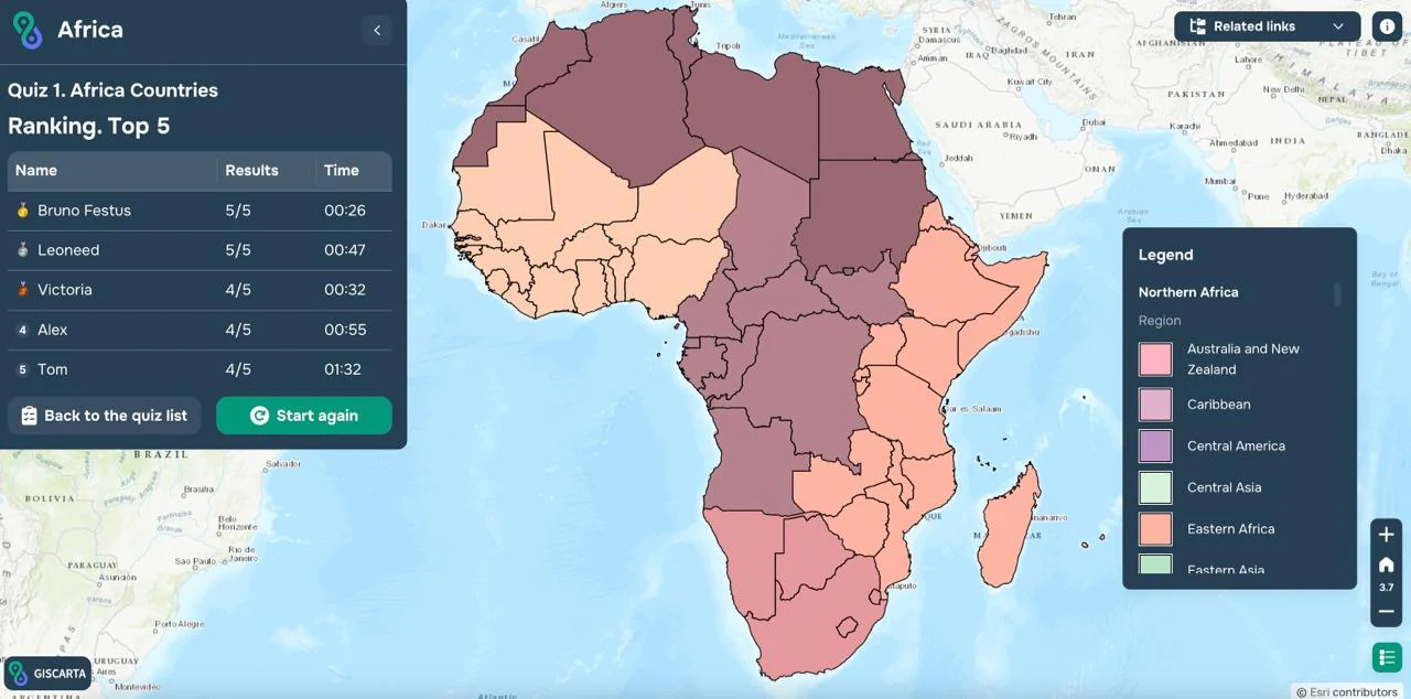
The “Africa Countries” quiz ends with a top-5 ranking by correct answers and time. Made the list? Save your name — no account needed.
Built-in timer
The clock starts with the quiz, and speed counts toward the ranking.
Link and QR code
Publish once and share it in a lesson, a chat, a slide or on a printed handout.
Your own data
Quiz on CSV, XLSX, GeoJSON, Shapefile, KML, GPX, GeoPackage or GeoTIFF layers.
Photos in questions
Show a landmark, a flag or a satellite view next to any question.
Reference links
Attach readings or sources; players see them in the corner during the quiz.
Your branding
Set your logo, title and a link below the logo — ideal for schools and museums.
Shuffled answers
List answers appear in random order, so memorising positions won't help.
Basemaps and legend
Pick a basemap, add a legend and map info, and set where the map opens.
Map quiz ideas for every topic
Every idea below works as a choose-on-the-map or a choose-from-a-list question. Start with world layers or upload the data your lesson already uses.
Countries and capitals quiz
“Click the country whose capital is Ulaanbaatar.”
On the map
Rivers, lakes and seas
“Which river flows through Baghdad?”
From a list
Mountains and volcanoes
“Click the highest mountain in Africa.”
On the map
History and empires
“Click the city that was the capital of the Byzantine Empire.”
On the map
Landmarks and UNESCO sites
“Find the ancient city carved into rose-red rock.”
On the map + photo
Climate and biomes
“Click the largest hot desert on Earth.”
On the map
Islands and coastlines
“Which is the largest island in the Mediterranean?”
From a list
Your city and local history
“Click the district where the old town stood in 1900.”
On the map
GIS for education
Run a map quiz in your next geography lesson
Before class
Build or reuse a quiz
Create a quiz in minutes or copy one from last term, using the layers your lesson already has.
During class
Show the QR code
Students start the quiz and answer one question at a time against the clock.
After class
Celebrate the top five
Put the leaderboard on screen and talk through the trickiest questions together.
A map quiz is a test where players answer by finding places on a map. In GISCARTA the questions run on a live, interactive web map: players click countries, cities, rivers or any object in your layers, or choose answers from a list.
How do I create a map quiz in GISCARTA?
Open My Quizzes, click New Quiz and start from scratch or copy a map project. Add your layers, write the questions, then save and publish to get a shareable link and a QR code.
Can I try the quiz maker for free?
Yes — sign up free, no credit card needed. Limits for projects and storage on each plan are listed on the pricing page, and students can apply for a dedicated student plan.
Do players need an account?
No. Anyone with the link or QR code can take the quiz, and players who reach the top five can save their name without registering.
What question types can I use?
Two. Choose on the map: players click an object on the map, and the correct answer comes from a layer attribute. Choose from a list: players pick from answer options, and more than one can be correct. Both types can include a photo.
Can I make a quiz from my own maps and data?
Yes. A quiz can show vector, raster and external layers. Upload CSV, XLSX, GeoJSON, Shapefile, KML, GPX, GeoPackage or GeoTIFF files, or copy a map project you already built.
How are quiz results ranked?
When players finish, they see the top-5 table, ranked by the number of correct answers and the time taken to complete the quiz.
Is it suitable for school geography classes?
Yes. Quizzes open in the browser, so you can post the link in your learning platform or project the QR code in class. They suit geography, history, biology, earth science and urban studies.
Do I need GIS experience?
No. GISCARTA is a no-code platform: you pick layers and click to set the answers. A video tutorial and step-by-step docs walk you through it.
Create your first map quiz today
No credit card. No GIS degree. Build it, publish it and share the QR code.